


Recommended:
- The Smolensk Conferences. A Preliminary Summary and Conclusion
- NEW STUDY: Putin's Russian inquiry into the Polish Air Force One crash in Smolensk
- 15 SIMPLE FACTS THE WORLD SHOULD KNOW
- Smolensk Reader's Digest. 23 pages, all the facts.
- Polish Military Intelligence was warned of a possible terrorist threat against one of the EU Member States' aircraft.
- Story behind the "1:24"
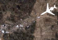
Who and why has positioned and oriented satellites onto the area of the plane crash in Smolensk? Has anyone wanted to make sure that satellite pictures from Smolensk did not show the entire truth? Months after the crash there are still far more questions than answers regarding the issue of satellite photos of the crash site.
“Gazeta Polska” talked with prof. Chris J. Cieszewski, author of one of the most interesting papers prepared for the Smolensk Conference held in October. Prof. Cieszewski is a researcher for the Warnell School of Forestry and Natural Resources, University of Georgia in the United States, and chief editor of two and member of three editorial committees of international scientific magazines, he works as a reviewer for 23 other international magazines in the industry. He is also a founder of the “Mathematical and Computational Forestry and Natural Resource Sciences” international paper of the Southern Mensurationists professional organisation, which associates biometry specialists from the southern part of the United States, and a co-founder of the “Biometry, Modelling and Information Sciences” international magazine. He has published over 120 scientific papers, which were quoted over 750 times in international research literature.
The conclusions drawn by prof. Cieszewski on the basis of a review of the available satellite pictures from Smolensk are especially interesting.
– We have carried out a review of pictures from the period that directly preceded the Smolensk plane crash and those that were taken in the days following the crash. The most important pictures are from April 5, 9, 11, 12 and 14, 2010 – says prof. Cieszewski.
– I find it particularly intriguing that the earlier high resolution satellite pictures (i.e. 50 cm) taken over the airport in Smolensk date back to a period as late as 2007. Since then, no such pictures have been taken of this area, and then suddenly on April 5 and 9, and then on April 11, 12 and 14, 2010, the pictures started to be taken successively one after the other – he added.
The scientist insists that this appears to be all the more puzzling as ordering satellite images for a given location, i.e. the so-called satellite tasking, has to be done 2 to 4 weeks before the photo may actually be taken (the satellite has to be moved to the desired location and assure coverage of the schedule of other clients, which is a particularly time-consuming task). And so if anyone ordered the execution of satellite imagery of the Smolensk airport between April 5 and 14 2010, then that person either must have known that something would be happening there, or it could also have been purely an astounding coincidence. It cannot be ruled out that theoretically someone with exceptional financial or political influence could have oriented the satellites onto the site close to Smolensk already after the plane crash, regardless of any existing schedules (for example to take photos of the plane debris and crash site); it should be emphasised, however, that the first photos were taken on April 5th, 2010, and so they were taken as long as five days before the tragedy.
Most likely after the crash all the photos, including the ones that have not been made available, had been turned over to the Polish services. Unfortunately, despite being part of the most circumstantial evidence related to the Smolensk tragedy, those photos have gone missing in one of the institutions subordinated to the prime minister. Those institutions keep accusing and exchanging blame on each other from hiding materials obtained from the USA, including the satellite images. The Military Counterintelligence Service, the Internal Security Agency and the Ministry of Interior - all have declared that they had submitted those materials to the prosecutor’s office on time; however the prosecutor’s office insists that…it has never received them.
On 29 July 2011, the late general Sławomir Petelicki said: “The Americans have evidence showing everything that has happened, frame after frame. They have recordings of everything that has been said and they know the truth. And now they are really surprised that Poland is not asking the USA for help, and if subsequently a Polish prosecutor asks for assistance form US authorities, he is immediately suspended from his duties. Any NATO report would be crushing for this prime minister and for the government, which would have to resign right away”.
The sudden activity of teledetection satellites (which were taking images) in April 2010 over Smolensk or rather their sudden excessive activity is one of numerous unsolved issues related to the analysis of satellite photos.
– It really seems that a lot of manipulating has taken place on the crash site within a few days following the tragedy – we are told by prof. Chris Cieszewski.
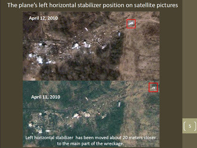
The most striking change was a visible shifting of the left plane stabiliser by 50m towards the centre of the crash site, which becomes visible in a comparison of images taken on April 11 and 12, 2010. Why has this been done? It is unclear. It is certain, however, that in the report drawn up by MAK (the Russian Interstate Aviation Committee) the stabiliser's position was identified according to the place in which it was found after it had been moved.
Prof. Cieszewski has carried out a detailed comparative analysis of high resolution pictures from April 11, 12 and 14, 2010. He found that apart from the stabiliser the position of at least seven other fragments of the aircraft were changed, and that they appear to have been moved and grouped in various places of the crash site.
The next unclarified issue is that on the pictures no machines may be seen, which in fact remained on the site for several days after the plane crash almost the whole time (this was confirmed by various reports, as well as pictures and videos taken on the ground). – On the site were giant machines, bulldozers, excavators, cranes, which should be clearly visible on satellite images. Yet none of those machines were visible on any of the available images taken by the satellites. This could suggest that somebody knew when those photos would be taken – says prof. Chris Cieszewski.
The scientist also points to the fact that the satellite images taken a short time before the Smolensk plane crash entail certain defects, which may not be easily clarified. For example the photo from April 5th, 2010, was taken at a very big angle making it particularly hard to perform the required analysis. On the other hand, the photograph taken on 9th April 2010 surprisingly failed to cover the part of the airport, close to which the Polish Tu-154 plane had crashed.
We asked prof. Cieszewski whether it would be possible that the pictures were also made on April 10, 2010 or even at the time of the crash itself, and whether they were only available by western government agencies. – Of course, this is indeed possible – replied prof. Chris Cieszewski, and added that if there really was such an intense fog during the crash (either natural or artificial) as reported by the witnesses, the satellite image would not and could not most probably show the actual crash.
Prof. Cieszewski warns that the above facts are not absolutely conclusive and as a scientist has to remain prudent in his assessments and conclusions.
Taking into account all those doubts concerning satellite imagery one thing appears to be almost certain: the spatial distribution and the range of the plane debris depicted on the photos and the way in which particular plane fragments had been destroyed, point much more to an explosion over the ground than a collision with the ground.
– Both top class literature in this respect, among others publications of Włodzimierz Abramowicz, PhD, engineer [recognised expert in mechanics and dynamics of structures, author of modern computer simulation methods in analyses of collisions of vehicles, vessels and airplane crashes deceased in 2012 - note of “GP”], as well as documentations of other plane crashes prove that an airplane having this structure (i.e. with a thin-walled shell) and made of this particular material would not have fallen apart into such tiny bits similar to a broken glass. In the majority of cases thin-walled shells tend to be crushed, broken, flattened etc., but not fully fragmented, as may be seen on satellite images from the crash scene – says prof. Cieszewski.
Source: Gazeta Polska
Authors: Leszek Misiak, Grzegorz Wierzcholowski
Date: 15.11.2012